Sunday, March 10, 2013

100 Adventures - Part 2

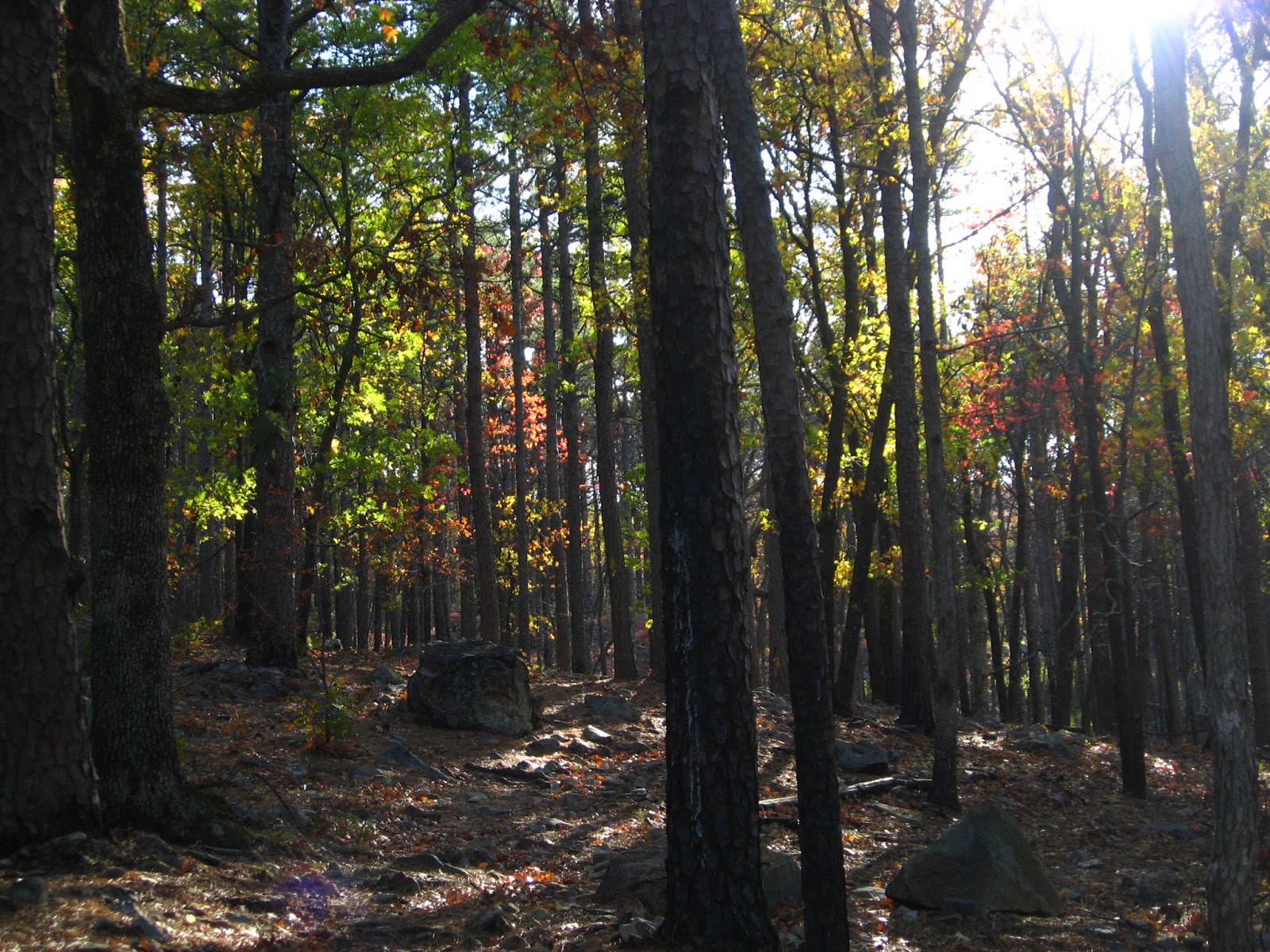
The challenge to experience 100 Adventures in 2012 culminated with one of the most beautiful hikes I've ever experienced.  The combination of terrain, time of year, and weather were the perfect recipe.  Long overdue, here is Part 2 of the 100 Adventures:

We started our journey when the moon was still a bright sliver in the early morning blackness.  Our little group was headed to SE Oklahoma to hike Horsethief Springs in the Ouachita Forest.  The trail is an 11-mile loop, which was ambitious for our meandering ways on a short, November day.  Plus, our adventures almost always include detours, and this one would be no exception.


2nd Largest Pine Tree in Oklahoma
The scenic drive took us though Wilburton, so we decided to swing by Robbers Cave State Park to visit the 2nd Largest Pine Tree in Oklahoma.  I've done a bit of online research since then, trying to find the 1st largest pine tree in Oklahoma, but with no success.  There were some shaggy mane mushrooms in various stages of autodigestion there.  If I would have known what they were at the time, we could have eaten them.  Since my foraging skills are a bit lacking, we left them alone.

Robbers Cave State Park
Our route continued along the Talimena Drive.  We had driven the entire 54-mile scenic drive two weeks earlier to catch the fall foliage, and the color was even more brilliant now, although some of the trees had already dropped their leaves on this blustery day.  We turned off the drive and stopped at Cedar Lake where we could pick up the trail.  There, we ran into friends who were camping and backpacking for the weekend.  We were invited to share lunch with them, but we now had about five hours of daylight remaining, despite our early start.  That tends to happen often when you take the scenic routes and stop for photographic opportunities along the way.  The journey is definitely at least as important as our destination on these adventures.
October 27, 2012
November 10th, 2012
December 29th, 2012


Talimena Scenic Drive


Horsethief Springs Trail took us through tall pine trees and red and gold deciduous trees.  We crossed a few semi-dry creek beds and climbed uphill to join up with the Ouachita Trail for a mile or so.  We passed through areas recovering from recent fires and dense new-growth pine groves.  One section of trail turned lush green with healthy grasses among rockslides.

Along the top ridge of the Ouachita Mountains, the trail became deep in colorful leaf litter.  I spotted a walkingstick among the leaves on the trail.  It was cleverly camouflaged with its surroundings, displaying the same fall colors as the leaves it consumed.  Once the first one had been spotted, then we started seeing them EVERYWHERE.  It was most definitely mating season for them, as they gathered in large, amorous groups.  It was difficult to walk, since they seemed to cover every foot of trail and tree.  I later discovered that there is an extreme infestation of them in the Ouachita Mountains, and their leaf consumption can kill the oaks and other hardwoods that they live among.  We unknowingly transported several along the trail, as we each caught one or more hitching free rides on our pant legs.


Our pace increased as we reached the halfway point and could see the sun getting lower in the sky.  It was impossible not to stop for breathtaking views of the colorful treetops as we peeked past the pines and into the hillside below.  Thankfully, the last three miles or so were mostly downhill, so we just had to be careful not to trip on the plentiful rocks that were on the path as we admired the beauty around us.

Just as the sky was changing from orange to pink to dark blue, we temporarily lost the trail.  As much as I had desired to spot a bear or cougar, I really didn't want to spend the night with them, exposed in the cold forest.  We backtracked until we spotted trail markers again and made it back to the car just as the last bit of light dwindled.


We had to make a quick stop back at the Cedar Lake campground, just to let our friends know that we survived the hike and covered more than ten miles in five hours flat, while still stopping to enjoy it.  Declining the camp food buffet, we chose to grab some gas station diner food on the way back home.  The sliver of moon guided the car as we journeyed back - exhausted, legs aching, and thrilled with the sights from the 100th adventure of 2012.
Just in time!

Where will your adventures take you this year? 

Thursday, January 10, 2013

100 Adventures - Part 1

When I first came to the realization that there are more than 100 weekend days in a year, I was surprised.  Shocked, really.  Can it be true that almost 1/3 of the year is weekends?!?  Add holidays to that and that's a lot of free days.  Free.  Carefree.  Free to do whatever I please.
Adventure #4:  Kayaking with loons and eagles at Lake Murray

This is the thought that spurred the "100 Adventures" challenge.  Why shouldn't we have 100 adventures in a year, since we have all of these days at our disposal?  Challenge accepted.

#30:  Spanish Canyon hike
Now, let me lay down some rules.  It has to be 100 different adventures.  The rope-wall yoga class at Yoga Home of Therapeutics where we hang upside-down suspended in our make-shift harnesses in downward dog and child's pose can only be counted as an adventure the first time.  The outdoor yoga class at Urban Agrarian, where we sometimes had to surrender the yoga mats to the Oklahoma wind, is another adventure - but only to be counted once, no matter how many times we greet the sun in salutations on the concrete pad outside the local food market.  
#38:  "Spokeswomen" at the Friendship Plant and Seed Exchange

There are some grey areas in the rules, too.  How many different adventures can you have in a single day, or on a single vacation?  When we played in and on the Blue Whale in Catoosa, posed at the Totem Pole Park in Foyle, hitched a ride on a stranger's boat on Grand Lake, and hiked at Natural Falls State Park; how many adventures should that count for?  One.  It was all on the same roadtrip.  The week spent kayaking in the Alaska wilderness and exploring glaciers was just one big adventure.  The day that I rode with the "Spokeswomen" on our inaugural bike ride to brunch in dresses with flowers on our handlebars, then later hiked to the Spanish Canyon with another friend, that counted as two separate adventures.  Basically, if there was a break in between, and maybe a wardrobe change, then I think they count as individual adventures.  Most days, the adventures all blended into one big mass of good times.
#47:  Eclipse at the Tallgrass Prairie and hike at Osage Hills State Park

#54:  Mani-pedi day with my niece
Of course, there are Family Days of Obligation, as my large, mostly-used-to-be-Catholic family refers to them.  The nieces and I had a few adventures of our own, but regular family get-togethers to see who is taller, compare who has the bigger belly or butt, and see how far we can revert to our pick-on-our siblings childhood ways - probably not really an adventure.  In other words, the adventure must be FUN.  I understand that these Family Days of Obligation, or regular obligations of life, might cut into these 100 weekend days, so weekday adventures are required.

#60:  Martin Park with the nieces
What adult has time for all of these adventures?  Well, I've never been accused of being an adult, so I don't know.  Make time.  It's important to my mental health to have a more-than-normal amount of playtime in the sun.  You may not personally require quite as much vitamin D, or quite the same level of adrenaline, or quite the travel distance to get to your places of adventure.  Maybe it is just a 30-minute swinging session in the park, or a pedicure in January when you are the only one that sees your toes.  Maybe it is a trip to the neighborhood pond to watch the ducks, or frisbee with the family at the newly revamped Myriad Gardens.  You don't have to go far, or take out a loan to pay for the gasoline, or don a helmet for an extreme sport.  Just do something you enjoy.  Share this time with friends, or find your own private adventure.  Remember those rules?  Forget those, make your own.  These are your adventures.  The new year just started, so resolve to make this happen in 2013. 
#81:  Viewing of private arrowhead collection after kayaking in Keota

Out of my 100 adventures in 2012, all but three of those were in Oklahoma.  Instead of running out of Okie adventures, my list to do and see and experience this year is even longer.  There were 15 unique kayak trips, 21 different hikes, multiple bike rides, climbing adventures, and live music experiences.  There was a photographic hunt for a snowy owl in Marland, a chicken farm tour in Tuttle, small town fairs and festivals, street parties, garden parties, and potlucks.  I have 9,416 pictures on my computer - just from last year - and they can only remind, but not capture the awe of these moments.

Stay tuned for the next blog post when I tell you about the 100th adventure of 2012.  I still had a month and a half to spare, too!  Want a hint?  The 100th adventure was in SE Oklahoma on the most beautiful hike I've ever experienced.

Tuesday, December 4, 2012

Hidden Treasure

The first time I met Randy, he brought a map out of the back room at the Wichita Mountains Visitor Center for my friend that was raised in Texas.  He said, "I have just the thing for you." and showed her the map.  "Look!  No words!"  I knew right away that I liked this guy.  No, not because he was bashing Texans - I happen to like the state and some of the people produced there.  I liked him because when I asked where we should hike that day, he didn't point us to the well-defined trails that are close to facilities and picnic tables.  He told us about little features of the wildlife refuge that aren't marked on the maps (with or without words).

Last weekend, Randy brought out a map of hidden treasures around the Wichita Mountains.  The map was produced by Steve Wilson in 1961 and can be found in the Library of Congress.  According to the map, there are scores of Spanish and outlaw loot to be found in southwest Oklahoma.  We will save these to be explored on future adventures.  We had another mission planned for this hike.

On this particular day, we were determined to find some silver, but not for our bank accounts.  The silver we were looking for is a three-inch cross that is affixed a few inches from the ground on the side of a rock.  Randy had told us about this cross on another hiking trip.  He said that a hiker accidentally discovered it as he was kicking aside some leaves.  Randy had seen the cross himself and did his best to direct us to it.

The "buffalo chip" rock formation
We left the visitor center and headed to the Sunset area of the park.  My hiking companion was confident that we would find it, but I wasn't so sure.  Our treasure-hunting arsenal consisted of a topo map, a park trails map, a compass, and some pictures of pictures on Randy's phone.  He had pointed us in the general direction and told us that the cross was on the ESE side of the rock.  We were supposed to look for a rock formation that looked like a large buffalo chip and go left (although, when he said "left", he pointed to the right side of the rock formation and insisted that it made perfect sense).  We had about three and a half hours of daylight and 59,020 acres to search for a three-inch cross barely above ground-level.  Piece of cake.

See Crab Eyes in the center?  Everything to the right of Crab Eyes was fair game.  Needle in a haystack?

Michael dramatically searching for the cross
The Sunset Trail (I guess?  There weren't any signs on the trail to actually indicate that it WAS the Sunset Trail) veered to the left and we took to the game trails on the right.  We crossed better-traveled trails and sometimes took the more traveled ones before ending up back on game trails again.  We passed the recognizable Apple and Pear rocks and kept Crab Eyes to our left.  Eventually, we could no longer see Crab Eyes and I was sure that our mission would fail.

Several times I would pull out my camera and scrutinize the picture of the picture of the buffalo chip rock formation and compare it to the scenery before us.  Every possibility was ruled out for one reason or another.  No, there are no trees on top of the rock.  No, the terrain in the foreground doesn't match.  No, the rock isn't that smooth, or that textured, or that color.  Finally, I spotted one that was a definite possibility.  It certainly looked like a buffalo chip to me, but this wasn't the first "buffalo chip" landmark that Randy had pointed out for us to find on our adventures.

The closer we got, the more real the possibility of a match became.  The thin trail we had been following continued on to the right, so we turned left and headed toward the giant buffalo chip.  We started exploring the right side of the rock formation, just as described.  Randy mentioned that the trees in the area had been burned, but so had a third of the refuge.  We referred to the horrible picture of a picture of Randy sitting on the rock with the cross and started kicking leaves aside and examining the rocks in the area.  It wasn't long before my hiking buddy hollered out in excitement.  I can't believe I ever doubted that we would find it.

Sure enough, there was the silver cross securely epoxied to the ESE side of the rock.  And, just a few feet away to the northwest was the tree growing up through the ring of a rusted wagon wheel rim, just as we were told.  I was in complete and total awe that we hiked an hour and a half into the refuge - following various trails and not - and went right to the spot we intended to find.  We were asked later if we had GPS coordinates to follow, and the answer is "no".

I've tried to research the story of the cross, but haven't found anything about it online.  My hiking companion looked on the geocaching sites and also found nil.  I would love to know who put it there, how long ago, and why.  For now, I have to just be satisfied that we found it.

Sunset Pool
We continued our hike and boulder-hopped around the backside of crab eyes and across open grasslands with numerous buffalo wallowing holes.  Our pace increased as the sun dropped behind the mountains and we made it back to the car just as the sunset show began.  It was another splendid adventure on a beautiful and warm December day.

The REAL hidden treasure!
The more hikes we do, the more adventures we discover for future explorations.  There are definitely hidden treasures in this part of the state, but I already found the best one.  The next time you are around the Wichita Mountains on a Sunday, stop in at the visitor center and ask for Randy.  He is more valuable than any lost loot.  And, if you're from Texas, he has a map that is easy for you to read.
Booty-ful


Sunday, October 28, 2012

Healing

This may be the dumbest thing I've ever done - and that's a LONG list.  I can't explain why I drank from the dark pool of water that smelled like rancid eggs, other than complete, blind trust in the advice of an Indian woman I had just met.  Immediately after sipping the surprisingly salty water, I looked around at the animal tracks and scat on the soaked earth that sloped towards the very pool I drank from.  "Oh, shit."

For three weeks, we had been planning a trip to the Wichita Mountains to explore the Parallel Forest.  We planned some other detours, since we knew that the forest wasn't very large.  We were lured by the excitement from the legends about the forest being haunted.  Supposedly, if you go there, you might feel disembodied spirits brushing past you, or hear Native American ceremonial drumming, or see figures in the trees performing Satanic rituals.  There is even a "witches' altar", formerly a Spanish arista.

One of the planned detours led us to making this potentially serious, gastrointestinal mistake.  We had read about the Zodletone Mountain and the mineral springs by the same name.  There is a macrobial observatory there, where research has been conducted since 2001.  The spring has created a microbial environment similar to environments that existed 2 billion years ago - when oxygen was absent from earth's atmosphere.  I know what you're thinking:  "Who wouldn't be interested?"  We have all made peace with our inner nerds.

While there is detailed information on the research done at these springs, there is surprisingly little detail on how to get there.  Our nerd-quartet came semi-prepared with printed maps of the area, as well as a state atlas.  Attempt One brought us to a dead end with nowhere to go but to turn left and drive through a recently harvested field.  We even tried driving a little distance through the field before deciding that this must not be the place.  On the other side of Zodletone Mountain, we ran across more farmland and even more fences and closed, locked gates.  We explored monarch-covered wildflower prairies and honed our barbed-wire limbo skills.  Still, no luck in locating the artesian spring.


There were two houses in the midst of the farmland surrounding Zodletone Mountain.  We pulled up at the first one and knocked on the door, hoping someone could steer us in the right direction.  No one answered, except a menagerie of small familial pups and one vocal siamese.  A young man had stepped out of the neighboring house, so we inquired if he knew where the springs were.  He replied in the negative, but said that his grandmother would know.  He told us to let ourselves in the house to ask her.  Hesitantly, we obeyed.

A red, woven Indian rug covered the floor and flowered bedsheets covered the couches.  Native American chants and drums blared from the kitchen stereo.  Grandmother Mabel rested in the recliner, with her right leg in a walking cast.  She pushed a wheelchair out of the way and got up with effort and a walker to greet us.  Mabel told us that over the past 35 years that she had lived there, a handful of people had stopped to ask directions to Zodletone Springs - but she wouldn't ever tell them how to get there.  She tells us this after giving us detailed instructions on how to find the springs.  She also warned us about the farmer that now owns the land, and the roads that are impassible on this rainy day (even with 4-wheel drive, she says), the gumbo-like mud that won't come off your shoes if you decide to walk the distance, and the rattlesnakes and water moccasins that will kill you before you could get back to the car.  She wished us well and asked us to come back by to let her know if we were successful.  Excited and nervous, we got back in the car.

The directions Mabel gave us led to a dead-end road, with a path to the left through a recently-harvested field.  She led us right back to Attempt One.  We continued through the field, with windows down in order to listen and smell when the springs were close.  Ripe sulphur filtered in, indicating that we must be near.  We trekked on foot and crossed a stream, hopped a fence, and slid through "gumbo" mud.  I recognized a low concrete wall from one of the pictures online.  We had found it.  Mabel had told us about the healing properties of the stream.  She had seen relatives crippled by arthritis restored to their mobile selves after months of drinking and bathing in the healing waters and mud from the spring.


I'm still not sure why Mabel chose to give us directions to the spring.  Whatever her reason, we all decided that we must stop back by to let her know that we found it - and to thank her.  We will never know if her surprise and excitement was due to the fact that we found it (safely), or that we stopped back by to let her know.

We continued on our way to the Parallel Forest, but had to cut our hike short because of the total downpour that lasted almost exactly from the time we got out to hike until we got back to the car.  We didn't get a chance to find the altar / arista, but we did get to witness the trees bubbling and creating soapy suds in the rain.

After changing to dry clothes, we explored the nearby town of Medicine Park.  There, we saw the most amazing sight - monarch butterflies gathered in clumps of a hundred or so in the trees.  This sighting only added to the mysticism of our day's adventure.  But, the most incredible part of the day was that not one of us suffered any ill-effects from drinking from Zodletone Springs!  It really must be healing after all!


Sunday, August 19, 2012

COOP Ale Works


I'm not too big on beer.  When I saw that there was going to be a Beer Fest at Riverwind a couple of weeks ago, I was mostly intrigued because of all of the local breweries that were going to be sampling their wares.  I had tried a few of the local beers, but since I'm admittedly not big on beer in the first place, it would take forever to sample them all, one pint at a time.  This was the perfect opportunity to taste-test a whole slew of Okie-brewed goodness. 

Half a dozen tastes later, I decide I will need to call it quits if I am going to drive home.  The event is winding down anyway.  That is when I meet "All it takes is a liver and a dream", and we decide that we should take a tour of one of our favorite local breweries - COOP Ale Works.

Fast forward two weeks and we join a handful of people on a rainy Saturday at the unassuming metal building that currently houses the COOP operations (at least until the bank signs a big check and they get to move to a much larger facility on S. Meridian).  The small "COOP Ale Works" sticker on the glass of the front door is the only indication that we were at the right place.  Co-owner, J.D. Merryweather greets everyone and quickly reminds each of them as they arrive that he isn't allowed to do any tastings, due to current laws.  Despite the warning, no one walks out.
J.D. explains how beer is first heated in the whirlpools...
...then the yeast is added and allowed to ferment in one of the "Jackson 5" tanks


The tour starts in the front of the warehouse, surrounded by floor-to-ceiling pallets of Horny Toad cans and shelves of different varieties of malt.  Jack Daniel whiskey barrels are wheeled in as space allows.  We move to the back of the warehouse where whirlpools and giant metal tanks turn simple ingredients into a finely-crafted beverage.  Buckets of sterilized water bubble as carbon dioxide is released from the brew in the tanks named after the Jackson 5 (and various other Jackson family, as operations expanded).  Alcohol and carbon dioxide are the by-products of the fermentation process, and the tanks can only hold 18 PSI.  J.D. shows us where the tedious canning and bottling take place in a small, four-person assembly line.  He also explains the difference between ales and lagers, for the beer-illiterate, such as myself.

Proof that the yeast is doing its job

COOP is proud of its local heritage (even though J.D. is originally from Ohio and admits that he has tried to leave Oklahoma on several occasions).  They participate in loads of local events and charitable functions.  Their website boasts of their focus on being local, sustainable, and high-quality/ low impact.  They were one of the first local businesses to be 100% wind-powered.  There are future plans to purchase hops grown here in Oklahoma, if the water-hungry crops are successful.  In addition, COOP prides themselves on over-doing the customer service side of the business - definitely a plus!

I asked about the COOP logo, since an anvil just isn't the first thing that comes to mind when you think about beer.  He explains that they are one of the few breweries that still brew in wooden barrels, which were hand-crafted with anvils.  The COOP name comes from a combination of a "coop"eration between the group of friends that started the company as well as the number of "co-op's" around Oklahoma and neighboring states.  While some of the beer label art is self-explanatory (Horny Toad, DNR, F5, and Native Amber), some of the others are a little more personal.  The Gran Sport Porter features a vintage Vespa, that was one of the 30 Vespas that he owned at one point.  ("Why 30?" I ask.  "Because I didn't have room for 31," he answers.)

Even though the current shop seem tiny in comparison to most brewing operations, it is exciting to see what this company has done in 3 1/2 years.  Oklahoma is now one of the top three brewing locations in the nation, and COOP is winning awards and building a brand that is gaining expanding recognition.  I'll raise a glass of my personal fav - the Gran Sport Porter - to that!  Cheers!

Wednesday, August 15, 2012

Quest for Water


We were driving through towns only heard about during severe weather coverage on television (okay, I mean the radio, since I haven't owned a TV in many years).  The kayaks were strapped firmly to the roof and were buckling as the heat made their plastic frames pliable.  Folks in towns like Custer City and Thomas stared and shook their heads, as if they had just seen a car with surfboards driving through Oklahoma.  Our likelihood of finding water to wet the boats was looking as grim as surfers seeking to catch their next wave on the inland seas. 

The current drought is going on two years.

Today's plan was just to paddle around at American Horse Lake.  On the way there, I mentioned that the last time I had visited, the water had dropped a good three feet in a matter of two weeks.  That was probably two or three months ago - before the mercury hit the hundred-teens. 

An hour's drive later, I make the last slight left to the lake and meet a new gate with a bright orange sign announcing "DANGER - RESTRICTED ACCESS" and forbidding entrance.  We got out and walked the last few hundred yards to what used to be the water's edge.  There was no lake.  There were hills of red dirt and shale.  Beer bottles from years past and entombed plastic tubs that held bait in a past life.  When we finally found water, it was a stagnant, green puddle.  There was no sign of the clear waters that had stolen my heart the first time I discovered this lake.  We would later learn that the lake was being drained for more work on the dam that was damaged during flooding several years earlier.  For now, we were rejected.  All we could do is return to the car and vow to come back without boats and armed with trash bags, so we could clean up my playground in anticipation of rains that will revive her and make her beautiful once again.
American Horse...Lake?
GPS, maps, and the Oklahoma Water Atlas are consulted and we redirect to Canton Lake.  All that I knew of Canton, was that this was the source that fills Overholser, Stinchcomb, the North Canadian River (oh, I mean the Oklahoma River), Lake Hefner, and my water bottle.  The backroads take us through dry farmland and past many unmarked dirt and gravel roads.  I'm always excited to drive on an Oklahoma road that I haven't ever seen before.  As my traveling companion says, "when plans fail, the journey begins".  Little did he know at the time that the plans would fail more than once on this day.

"ROAD CLOSED TO THRU TRAFFIC" the sign read, just past the sign that pointed the way to Canton Lake.  Well, we had been debating whether to go to Canton Lake or Foss Reservoir, so the next choice was obvious. Besides, the map shows that we would be crossing the South Canadian River, so we could always just stop there and slide the boats down the side of the bridge and launch into the sandy riverbed. We recalculated our route.

The wide bridge announced the South Canadian River crossing, but we peered over the sides and couldn't see any water in either direction.  Not a puddle, not a ribbon of stream, not a drop.  I was beginning to think that the townfolk in their pick-up trucks were right about our deteriorated mental condition.  What were we thinking when we loaded boats and set out to go kayaking today?
South Canadian "River" to the East

South Canadian "River" to the West

I crossed my fingers and questioned my loyalty to the sun gods.  We need clouds and rain, too.  Why hadn't I realized this before today?  Oh, what have I done?!?  I search for upbeat tunes and continue speeding across dusty towns with more people in the cemetery than the last census.  One town boasts that it is storm-ready and I wonder what that means.  Union Pacific trains stretch for miles in their stillness, with just enough gaps to keep from blocking the numbered county roads.  I wonder if there will be another gate, another roadblock, or another dry patch of land awaiting.  There was no Plan E.

Blinding sun reflected off whitecaps and sparkling white boats bouncing skiers.  The three-mile earthen dam (one of the largest earthen dams in the world) wasn't doing a "dam" bit of good, since the water had receded several feet from the foundation.  But, there was water, and lots of it.  Probably not 63 miles of shoreline, as the Oklahoma Water Atlas boasted, but there was still plenty to share. 
No big boats launching here!
I already had the launch site picked out on the map - the furthest boat ramp from the dam, and the one bordering the Washita National Wildlife Refuge.  There was only one other boater in this part of the lake, and they were anchoring for a walk on the sand and a dip in the inviting water.  Our kayaks splashed their way across the lake against the wind.  The drips of water blown from the paddle blades were welcomed on hot skin.  This was nothing like the quiet little pond that we were originally trying to reach.  Good thing that we are Oklahomans and are resilient, stubborn, and still able to evolve.  We will make it work, and we are going to enjoy this journey, wherever it takes us. 

These people are Oklahoma-ready!